Équipement et logiciel pour des études géophysiques: conception, fabrication, soutien, fourniture
ZondST2d — Logiciel de traitement et d’interprétation de données sismiques 2D
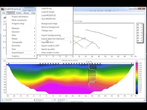
ZondST2D est conçu pour l'interprétation 2D des données de tomographie sismique sur des ondes réfractées et réfléchies (variantes terrestres, entre forages et aquatiques).
ZondST2D fait partie de la famille de logiciels Zond avec une interface unifiée et une séquence de traitement des données. Il est facile de commencer à travailler avec ZondST2D si vous avez de l'expérience dans le traitement avec tout autre produit Zond. La compatibilité des formats de données au sein du package logiciel Zond permet de combiner des données géophysiques provenant de différentes méthodes et sources afin d'obtenir des modèles géophysiques beaucoup plus stables et fiables.
Famille de logiciels Zond :| ZondST3D | Conçu pour l'inversion 3D des données de tomographie sismique (premiers temps d'arrivée) et sismique de réfraction. |
| ZondIP1D | Conçu pour l'inversion 1D des données de SEV et SEV-IP. |
| ZondRes2D | Conçu pour l'interprétation 2D des données de résistivité électrique et de polarisation induite (ERT et IP). |
| ZondRes3D | Conçu pour l'inversion 3D des données de résistivité et de polarisation induite en variantes terrestres, en forage et marines. |
| ZondProtocol | Conçu pour la création de protocoles, le contrôle des mesures et la visualisation des mesures ERT ainsi que l'évaluation de la qualité des données. |
| ZondMT1D | Conçu pour l'inversion 1D des données de magnétotellurique (MT), audiomagnétotellurique (AMT) et radiomagnétotellurique (RMT). |
| ZondMT2D | Conçu pour l'inversion 2D des données de MT, AMT et RMT. |
| ZondGM2D | Conçu pour l'inversion multiprofil 2D des données gravimétriques et magnétiques. |
| ZondGM3D | Conçu pour l'inversion 3D des données gravimétriques et magnétiques. |
| ZondTEM1D | Conçu pour l'inversion 1D des données électromagnétiques transitoires (TEM) pour divers systèmes d'observation avec lignes et boucles. |
| ZondTEM2D | Conçu pour l'inversion 2D des données de sondages EM dans les domaines temporel et fréquentiel. |
| ZondSP2D | Conçu pour l'inversion 2D des données de potentiel spontané. |
| ZondST2D | Conçu pour l'interprétation 2D de la tomographie sismique (ondes réfractées). Modules : MASW, tomographie d'atténuation, milieu stratifié, anisotropie. Nakamura (HVSR) est inclus. |
| ZCGViewer | Conçu pour le calcul et la visualisation des graphes de résistivité apparente obtenus avec divers systèmes de prospection électrique. |
Le logiciel nécessite un système d'exploitation Windows 98 ou une version ultérieure.
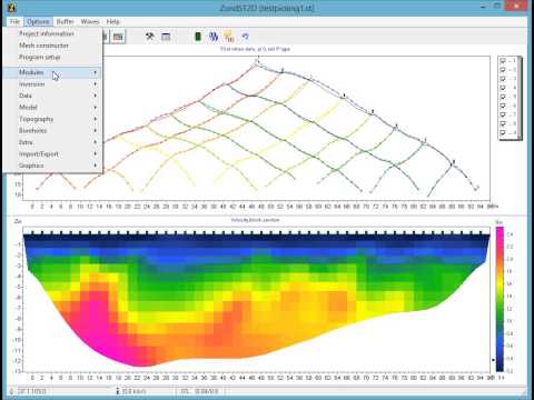
Les modules suivants sont inclus dans ZondST2D :- Tomographie sismique
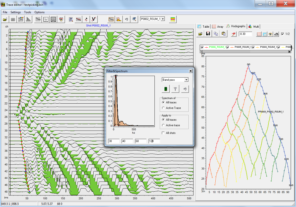
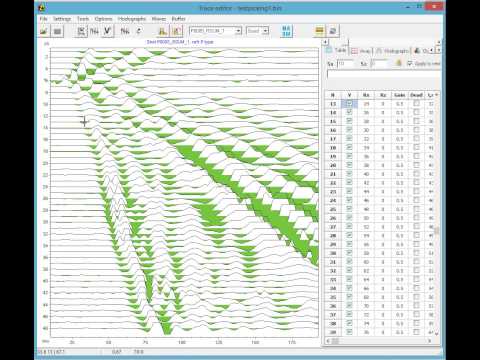
- Sélection des premières arrivées sur les sismogrammes
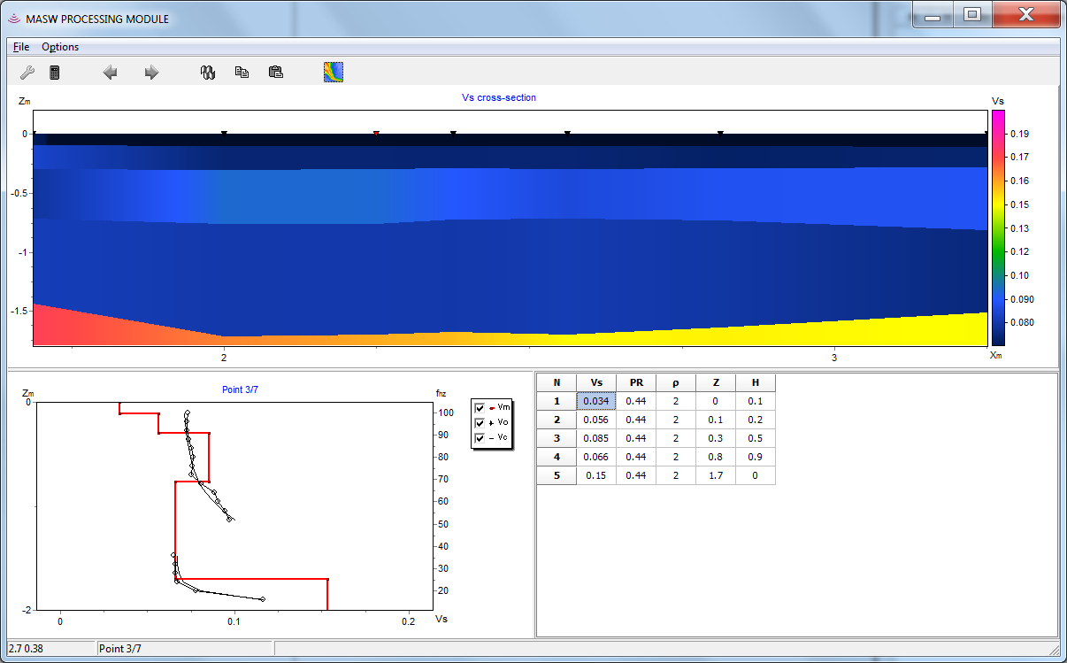
- MASW-ReMi — traitement et interprétation des données d'ondes de surface
- Modélisation directe et inversion des ondes de réfraction dans un milieu stratifié arbitraire
- Inversion des amplitudes
- Tomographie sismique sur les temps d'arrivée des ondes réfléchies
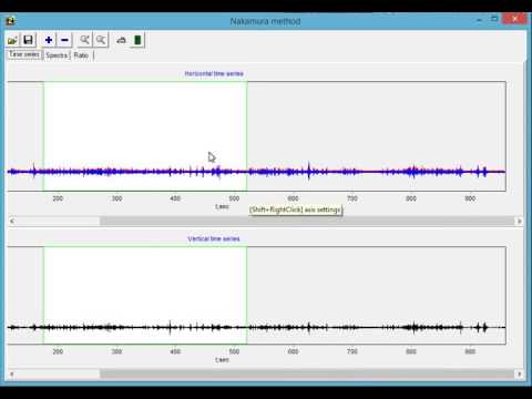
- Module pour la méthode de Nakamura
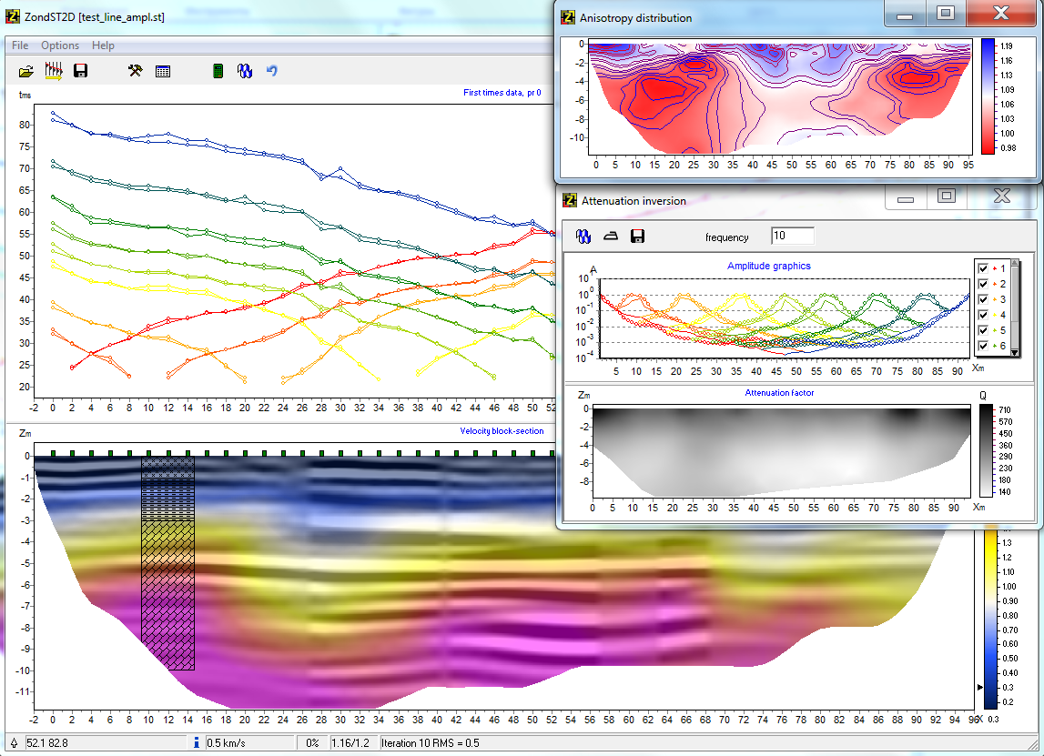
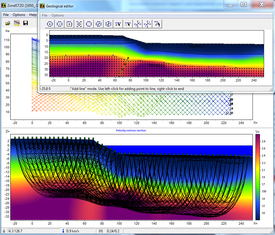
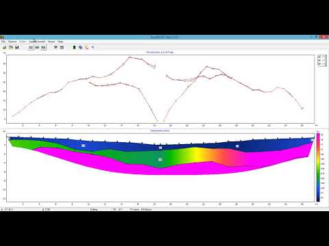
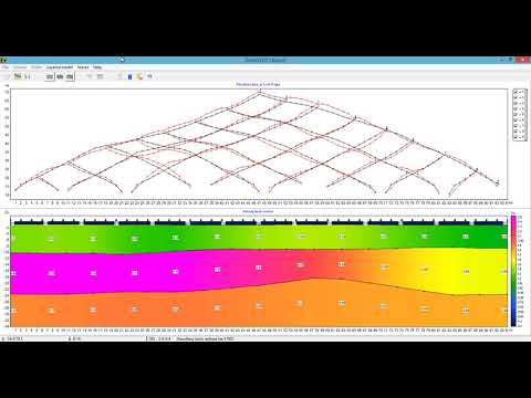
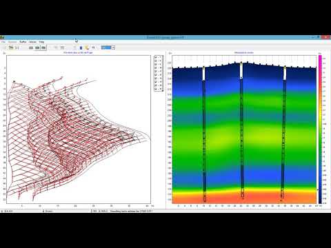
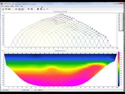
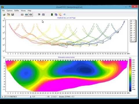
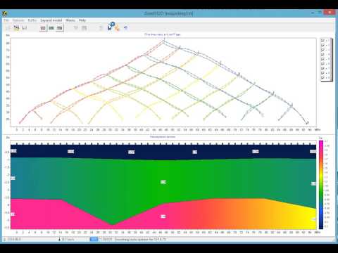
Le module de tomographie sismique est une solution prête à l'emploi pour la tomographie sismique qui résout un large éventail de problèmes allant de la modélisation mathématique et l'analyse de sensibilité à l'inversion et à l'interprétation des données de terrain.
L'algorithme du plus court chemin est utilisé pour résoudre le problème direct du traçage des rayons. Cet algorithme se caractérise par des calculs rapides et une précision contrôlée. La méthode permet de calculer le plus court chemin de l'onde réfractée. La combinaison des chemins des rayons les plus courts entre la source et le récepteur au réflecteur permet de générer un chemin d'onde réfléchie pour chaque frontière. Une section de la frontière avec le temps total de passage minimum entre la source et le récepteur est sélectionnée comme point de réflexion.
L'algorithme de traçage des rayons est mis en œuvre de trois façons : 1. Approximations par rayons. Vitesse constante dans une cellule. 2. Approximations par rayons. La vitesse à l'intérieur d'une cellule change de manière linéaire. Les vitesses sont définies dans les nœuds. 3. Modélisation d'un canal de rayon à rayon variable. La vitesse à l'intérieur d'une cellule change de manière linéaire. Les vitesses sont spécifiées dans les nœuds.
Le module de tomographie sismique permet d'obtenir des coupes de vitesse pour les ondes de pression et de surface. Les sources et les récepteurs peuvent être placés au sol, à la surface de l'eau, au fond marin ou dans des forages. Il est également possible d'utiliser le module pour l'interprétation des données de profilage sismique vertical (VSP). En plus de l'estimation des coupes de vitesse, une reconstruction de la distribution de l'anisotropie des vitesses a été mise en œuvre. Le programme utilise une version simple du rapport d'anisotropie des vitesses sismiques — Vx/Vz.
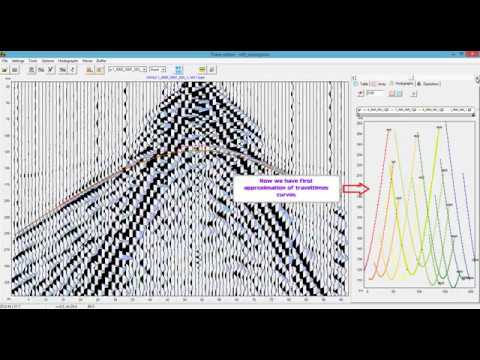
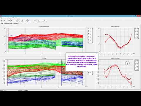
Sélection des premières arrivées sur les sismogrammes L'interface du module est conçue pour simplifier et automatiser le processus de sélection des premières arrivées. Le module offre une variété de méthodes de visualisation et un accès immédiat aux fonctions les plus courantes. L'utilisateur peut sélectionner simultanément plusieurs types d'ondes réfractées Vs, Vp et jusqu'à 3 ondes réfléchies. Le traitement des données est optimisé pour une utilisation conjointe des ondes P et des ondes S réfractées.
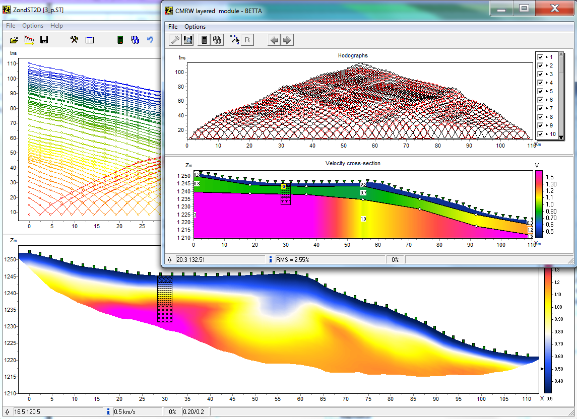
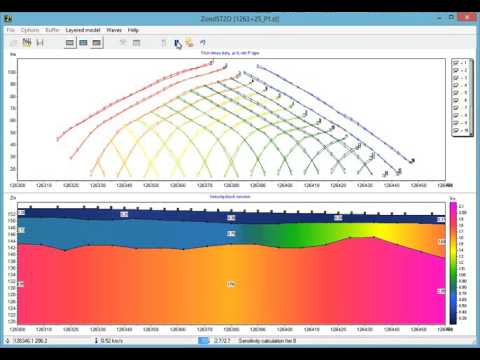
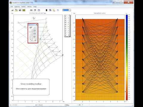
Modélisation directe des ondes de réfraction Le module est conçu pour obtenir des sections stratifiées arbitraires selon la méthode des ondes réfractées (ou réfléchies). La section de vitesse est définie par un ensemble de couches avec une géométrie des couches libre et une distribution de vitesse arbitraire le long du profil dans chaque couche. La complexité de la géométrie de l'horizon est contrôlée par le nombre de nœuds. Toute couche peut être réfléchissante et réfringente, ou seulement réfringente. L'application met en œuvre une solution précise pour un milieu stratifié arbitraire. Le rayon passe selon le principe de Fermat, qui décrit correctement la physique du processus, contrairement à la méthode t0, où l'onde glisse toujours sur le bord de réfraction. Le module permet de modéliser les temps d'arrivée des ondes réfractées et réfléchies et de résoudre le problème inverse des temps observés, à la fois de manière combinée et séparée. L'inversion conjointe des données SEV, MT, AMT, RMT, TEM, des levés gravimétriques et magnétiques est disponible dans le module.
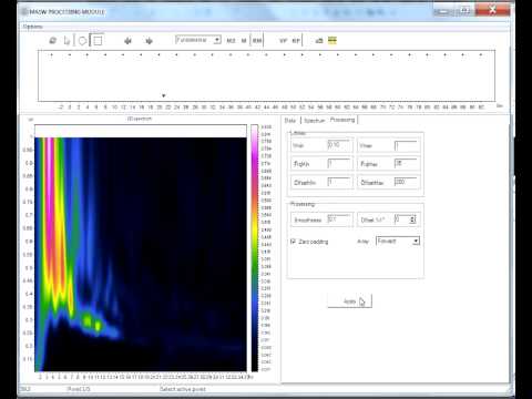
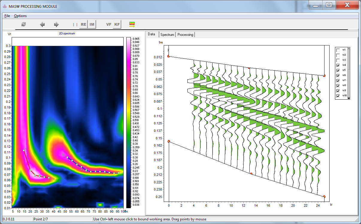
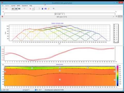
L'analyse de la dispersion des ondes de surface, mise en œuvre dans le module MASW, permet d'obtenir des profils de vitesse Vs à partir des données de terrain. Le programme offre un cycle complet de traitement des données, depuis l'estimation des courbes de dispersion jusqu'à la construction des sections de vitesse. L'inversion multimodale est également disponible.
Le module Inversion des amplitudes met en œuvre l'algorithme de tomographie d'atténuation et permet d'obtenir une section du paramètre d'atténuation Q à partir des valeurs des amplitudes des premières arrivées. La solution du problème est basée sur une section de vitesse préalablement obtenue. Les valeurs des amplitudes des premières arrivées sont sélectionnées simultanément avec les temps.
Le module additionnel GraviMagnétique permet une combinaison efficace des levés gravimétriques et magnétiques avec la section de vitesse dans un cadre unique. Ce cadre basé sur la section sismotomographique est rempli automatiquement ou manuellement avec des données gravimétriques et magnétiques.
L'application spéciale Nakamura fournit une estimation des spectres, une analyse des micro-séismes, réalise la génération des spectres du rapport H/V et la modélisation des sections verticales Vs 1D.
Des informations détaillées sur les fonctions de ZondST2D peuvent être facilement trouvées dans le manuel de l'utilisateur et dans les didacticiels vidéo. Vous pouvez également obtenir une version de démonstration via le lien ci-dessous.
Configurations :
Trois versions de ZondST2D sont disponibles :
ZondST2D Full — Version complète — toutes les fonctions et modules sont inclus.
ZondST2D Refraction — Version Réfraction — configuration avec toutes les fonctions nécessaires au traitement des données de tomographie sismique terrestre.
ZondST2D MASW — Version MASW — inclut toutes les fonctions pour le traitement des ondes de surface et la méthode de Nakamura.
Versions de ZondST2D et leurs fonctions :
| Modules et fonctions | Full | Refraction | MASW |
| Module de tomographie sismique pour le traitement des données terrestres | + | + | - |
| Module de tomographie sismique pour le traitement des données terrestres, de forage, entre forages et marines | + | + | - |
| Calcul de l'anisotropie | + | + | - |
| Module de sélection des premières arrivées | + | + | + |
| Module MASW — traitement et interprétation des données d'ondes de surface | + | - | + |
| Module de modélisation directe des ondes de réfraction — milieu stratifié arbitraire | + | + | - |
| Inversion des amplitudes | + | + | - |
| Tomographie sismique sur les temps d'arrivée des ondes réfléchies | + | + | - |
| Méthode Nakamura | + | - | + |
| Inversion conjointe avec des données électromagnétiques (SEV, MT, AMT, RMT, TEM), gravimétriques et magnétiques | + | + | - |
Autre
Joint inversion of Rayleigh and Love dispersion curves in ZondST2D (24.10.2021)
What you can have with ZondST2D spent 20 min only (3 shots survey) (23.06.2020)
Picking and inverting of reflected data in ZondST2D (04.06.2020)
ZondMT2D's MT-editor for MT sounding data postprocessing (20.05.2020)
Joint inversion of MASW and seismic refraction data (21.06.2019)
High resolution cross-hole 2D seismic tomography (24.03.2019)
HVSR data inversion (08.11.2017)
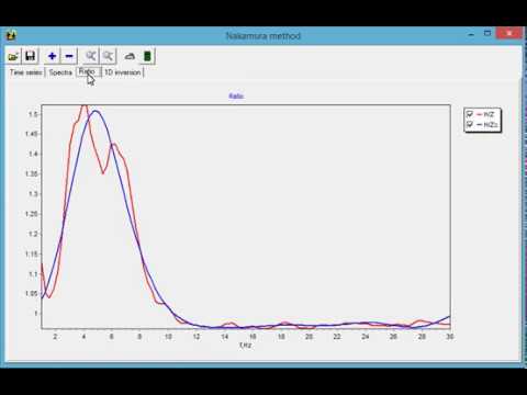
Application for Nakamura method (14.12.2016)
Cross gradient joint inversion of seismic refraction data Vp and Vs in ZondST2D (17.07.2016)
Amplitudes inversion in ZondST2D (29.06.2016)
Joint inversion of MASW and refraction seismic data (29.04.2016)
ZondST2D seismic software. Overview 2016 (6.04.2016)
Inversion of first break amplitudes in ZondST2D (6.11.2014)
ZondST2D overview of features. Part II. (11.10.2014)
New features of ZondST2d picker (10.10.2014)
Forward modeling in ZondST2d (22.06.2014)
Joint interpretation ERT and refraction seismic data (29.05.2014)
New features of Zond 2d softwares (25.05.2014)
New features of ZondST2D for MASW and ReMi (28.10.2013)